
Blog
Kashmir’s hydropower push raises disaster fears
Estimated reading time: 4 minutes · Last updated: 2026-08-24
Residents of Kishtwar in Jammu and Kashmir say a renewed push to build dams is heightening flood and landslide risk after flash floods on Aug. 1 left roads and homes under water. Tarushi Aswani reported for Nikkei Asia that seven dam projects are under way on rivers that feed the Chenab, which flows from Indian Kashmir into Pakistan. Locals speak of repeated cloudbursts, floods and slope failures in recent seasons and link those events to altered runoff patterns and construction activity. The dispute now sits at the intersection of rural safety, infrastructure ambitions and cross‑border river management.
Key takeaways
- Tarushi Aswani reported for Nikkei Asia that seven dam projects are under way in Jammu and Kashmir.
- Flash floods on Aug. 1 swept through Kishtwar district, washing away roads and damaging homes, a local trader named Iqbal Ahmad told the reporter.
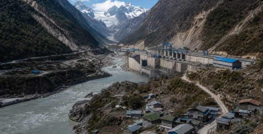
- The Chenab River, photographed on May 6, 2025, flows from Indian Kashmir into Pakistan, raising downstream concern.
- Locals in Kishtwar say they have faced repeated cloudbursts, floods and landslides in recent seasons, according to the Nikkei Asia report.
Table of contents
Where projects and recent floods converge
Kishtwar district sits on tributaries that feed the Chenab River, a transboundary watercourse that runs into Pakistan. Tarushi Aswani, writing for Nikkei Asia, described how flash floods on Aug. 1 submerged roads and damaged houses in the district. A Reuters photograph dated May 6, 2025, shows a dam on the Chenab near Chanderkote, underlining that hydropower infrastructure already exists along the river system. Local traders and residents surveyed during the reporting described the Aug. 1 floods as part of a string of intense rain and slope failures in recent seasons.
The reporter identified seven dam projects currently under way in the region, and residents say those projects and related access works are concentrated where slopes are steep and drainage is rapid. That physical proximity is the immediate source of alarm in villages downstream of construction sites.
Why locals link dams to landslides and floods
Residents and local witnesses told the reporter that heavy earthworks, blasting and new roads for dam construction have altered how water runs off hillsides. Changes to drainage channels and removal of vegetation increase the chance that intense cloudbursts will trigger debris flows and slope collapse. The Nikkei Asia reporting records repeated instances of cloudbursts, floods and landslides that communities say have become more frequent during the construction period.
Those on-the-ground accounts do not substitute for formal hazard assessments, but they do reflect a pattern familiar in mountain hydrology: excavation and altered surface cover change runoff timing and peak flows. In Kishtwar, villagers linked specific episodes of road washouts and shop damage to nearby works, and one named local, Iqbal Ahmad, described seeing roads disappear under fast-moving water during the Aug. 1 event.
Cross-border and policy implications
Because the Chenab flows into Pakistan, residents and observers worry about impacts beyond local valleys. Nikkei Asia's reporting notes that downstream connectivity makes dam siting a matter of bilateral consequence, even where the immediate concern is village safety. The hydropower push in Jammu and Kashmir is part of a broader national effort to expand generation capacity, but in this terrain that ambition intersects with fragile slopes and concentrated monsoon rainfall.
Managing that trade-off requires published hazard assessments, clear mitigation measures during construction and transparent monitoring of river flows. The reporting highlights a gap between large infrastructure planning and village-level experience, with Kishtwar's repeated flood episodes now central to public debate over how and where dams should be built.
What could move this either way
The case for
- If projects include strengthened slope stabilization and improved drainage, construction can proceed with reduced local hazard.
- Formal, published environmental and hazard assessments could provide data to redesign works and lower downstream flood peaks.
The case against
- Continued earthworks without mitigation could raise the frequency of landslides and flash flooding in Kishtwar's valleys.
- Lack of transparent monitoring and cross-border coordination may fuel tensions with downstream communities in Pakistan.
What to be careful about
- Increased landslide and debris-flow risk from excavation and road-building on steep slopes in Kishtwar.
- Higher downstream flood peaks if runoff timing is altered by construction in tributary catchments.
- Cross-border impacts on Pakistan from altered flows in the Chenab River, which could heighten diplomatic friction.
The bottom line
Nikkei Asia's on‑the‑ground reporting from Kishtwar spotlights a recurring dilemma: hydropower is a national priority, but in steep, rain‑soaked valleys the engineering that enables dams can also raise local hazard. The piece documents seven projects and a recent Aug. 1 flood that villagers say reflects a growing pattern of cloudbursts, floods and landslides. Addressing those risks will require published hazard assessments, transparent monitoring of river flows and mitigation during construction. Without those measures, the push for generation risks greater local damage and heightened downstream tensions along the Chenab.
What to watch
- watch for publication of environmental or hazard assessments for the seven dam projects; no date has been set.
- watch for an official disaster assessment or relief update from Kishtwar authorities on the Aug. 1 floods; no date has been set.
Frequently asked questions
How many dam projects are under way in Jammu and Kashmir?
Tarushi Aswani reported for Nikkei Asia that seven dam projects are currently under way in the region.
Where did the Aug. 1 flash floods occur?
The flash floods struck Kishtwar district in India-administered Jammu and Kashmir on Aug. 1, washing away roads and damaging homes, according to the reporting.
Why do residents blame dams for increased landslides and floods?
Residents told the reporter that earthworks, new roads and vegetation removal for dam construction change drainage patterns and can make slopes more prone to debris flows during cloudbursts.
Related reading